Point clouds - Everything you need to know
Ever wondered how to capture the accurate measurements and details of real-world objects or spaces? Point clouds hold the answer. These three-dimensional representations are created by gathering numerous data points and measurements, providing an incredibly precise portrayal of physical environments. From architecture to manufacturing, this technology has sparked a revolution across various industries, enabling unparalleled accuracy in design and analysis. With their ability to capture intricate details and dimensions, point clouds have become indispensable for professionals seeking comprehensive insights into their projects In this article, we will embark on a journey to uncover the essence of point clouds - to understand what they are, how they are created, and what applications they are used for.
What are point clouds?

The point cloud is a collection of data in a 3D coordinate system (xyz), representing the external surface of an object or environment. Imagine each point as a tiny dot floating in space, and when you gather millions or even billions of these dots together, they form an incredibly detailed 3D cloud. Each contains important information about its position in space.
Point clouds are created using advanced technologies like laser scanning, LiDAR, or photogrammetry. These methods involve capturing data points from various angles to build a comprehensive 3D representation.
How to create a point cloud
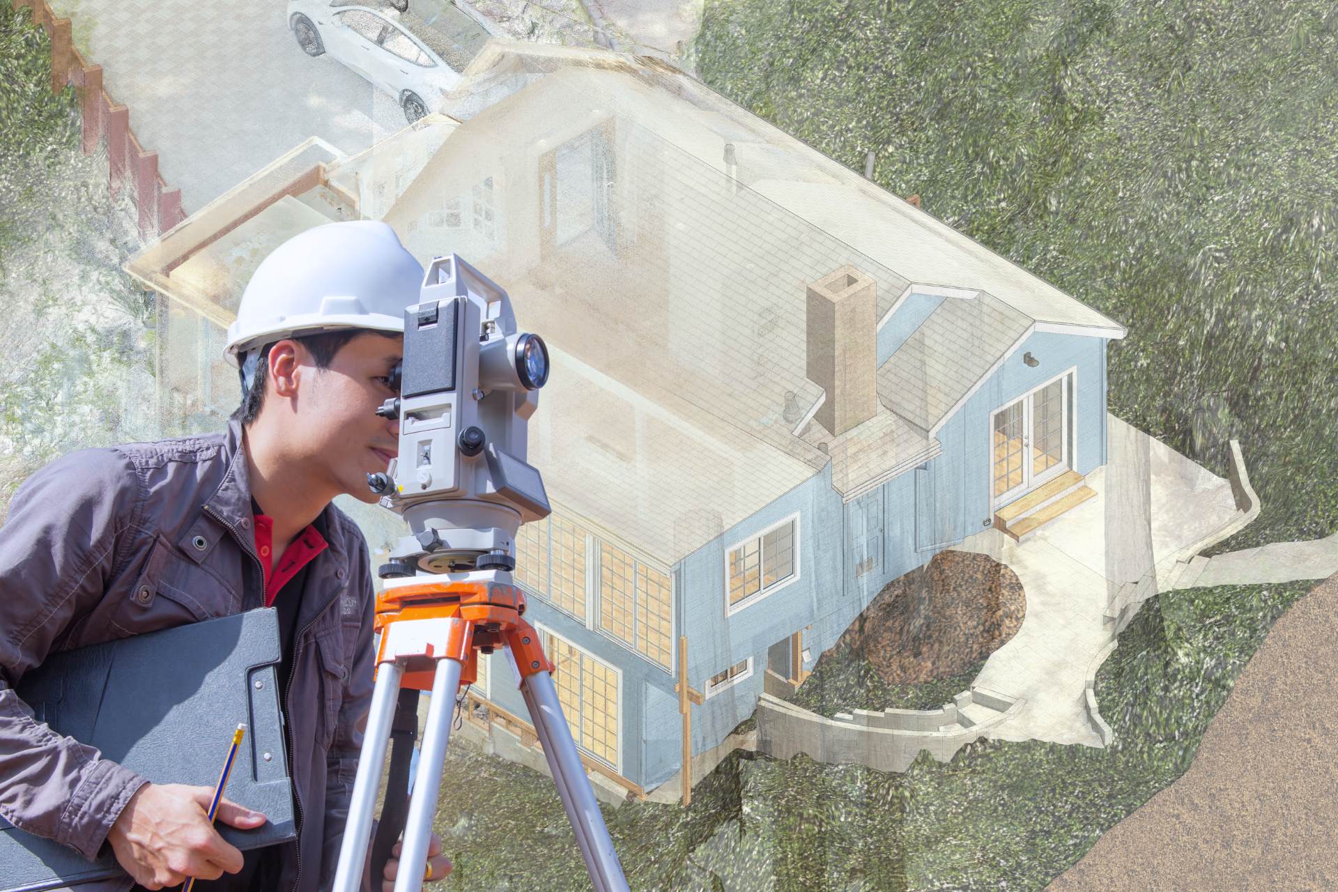
In the dynamic realm of construction, where precision and accuracy are paramount, generating point clouds has become an irreplaceable tool for capturing the details of a physical space in a digital format. Various techniques are employed to create these three-dimensional representations, offering construction professionals a powerful means to streamline processes, enhance project visualization, and improve overall project efficiency.

1. Laser Scanning Technology
Laser scanning stands at the forefront of point cloud generation. This technology utilizes laser beams to measure distances and create highly detailed, accurate point clouds of structures and environments. Construction sites are scanned from multiple positions, capturing millions of data points that collectively form a comprehensive and precise representation of the site. Different scanners can do the same type of scanning with variations in accuracy and time spent, depending on the size and purpose of the building.

2. Photogrammetry
Photogrammetry involves capturing detailed images of a construction site from multiple angles and then using specialized software to triangulate the position of objects in three-dimensional space. This technique is particularly useful for creating point clouds in outdoor environments and large-scale construction projects. Advanced cameras and drone technology are often employed to ensure comprehensive coverage. This might not always offer the best accuracy or the same level of usability, however, with the tech development, photogrammetry advances too.

3. LiDAR scanning.
This technology uses a laser beam that is reflected off the surface of objects and returned to the scanner. By analyzing the time it takes for the beam to reflect and return, the distance to the object as well as its shape and size can be determined. This method is highly effective for capturing detailed data in real time, reducing the time required for on-site data collection. A lot of modern scanners and software will generate a point cloud dataset automatically for an extra charge, for others - the post-production effort should be involved.

4. Structured Light Scanning
Structured light scanning involves projecting a pattern of light onto the surfaces of objects or structures and then capturing the deformations of this pattern with cameras. This technique is useful for generating detailed point clouds of smaller construction components, such as building components or interior spaces, their slopes, and deviations, where high precision is crucial.

5. Unmanned Aerial Vehicles (UAVs) or Drones
Drones equipped with cameras or LiDAR sensors are increasingly employed for aerial surveys in construction. By flying over a construction site, drones capture images or LiDAR data that can be processed to create detailed point clouds. This technique is particularly effective for monitoring construction progress, assessing site conditions, and conducting surveys in challenging or inaccessible areas.
The applications for point cloud data
Point cloud data, with its ability to capture intricate details of physical spaces in three dimensions, finds diverse applications across various industries. Here are some notable applications:

Construction and Architecture
Point cloud technology is crucial in construction and architecture for creating accurate 3D models of existing structures. This enables architects and construction professionals to have a detailed digital representation of buildings, landscapes, or any physical environment. By using specialized equipment such as laser scanners or photogrammetry systems, point cloud data can be collected to generate highly detailed measurements.
This technology allows for the creation of precise CAD models, which are essential for various aspects of construction projects. These models aid in visualizing designs, identifying potential issues, and ensuring that new structures align with existing ones seamlessly.
Architects and engineers use the data for as-built documentation, clash detection (identifying potential conflicts in design), and creating accurate models for renovation or expansion projects.

Surveying and Mapping
The use of point cloud technology in surveying enables professionals to collect vast amounts of data points within a short timeframe. This capability enhances the precision and efficiency of mapping terrains, areas, surfaces, and coordinates. By utilizing point cloud data for terrain modeling, surveyors can accurately represent the natural features of a site or ground surface. It facilitates the creation of precise surface models by capturing millions of individual points that collectively form comprehensive representations.

Urban Planning and Development
In urban planning projects, the use of point cloud data reduces the need for manual measurements. This not only saves time but also minimizes human error, leading to more reliable survey results. For example, when creating a new neighborhood layout or designing road systems within a city plan, accurate topographic information derived from point cloud data is crucial for ensuring that infrastructures are built on stable ground with optimal slope conditions.
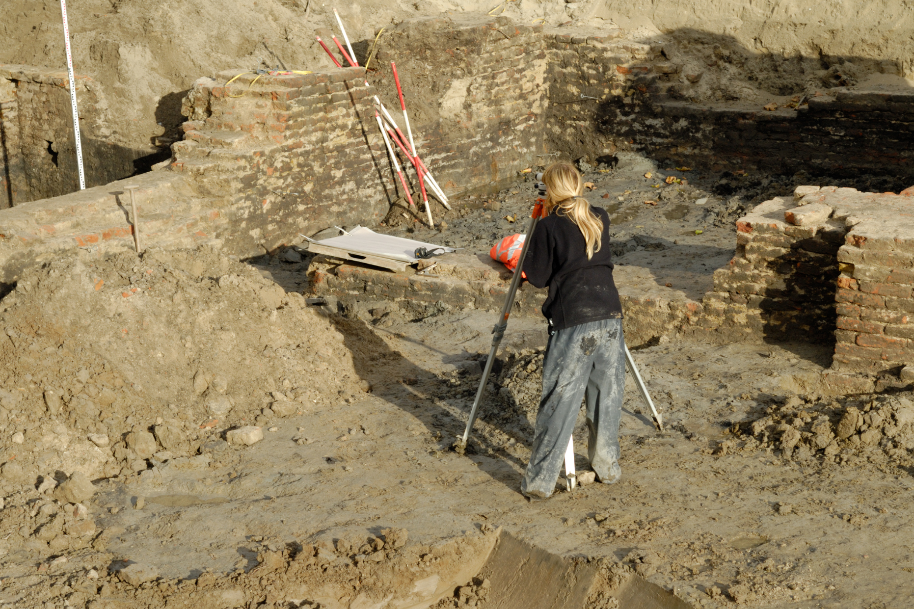
Archaeology
For heritage preservation and archaeology, point cloud applications are invaluable tools for documenting and preserving cultural artifacts and historic sites. By capturing millions of points in 3D space, point clouds enable precise digital representations of objects or structures that may deteriorate over time or be at risk from natural disasters or human activities.
For instance, architectural historians can use AR to superimpose historical building reconstructions onto existing landscapes based on point cloud data, allowing people to visualize how the area looked in the past.
Also, facilitate the restoration process by providing comprehensive visual information about damaged monuments or artifacts.
Data Formats and Storage
Point cloud datasets can be stored in multiple file types, popular formats are RCP, RCS, LAZ, PLY, or XYZ. Each format offers unique advantages and is compatible with different software applications and tools.
When working with point cloud data, it's crucial to consider the compatibility of the file format with the specific software being used. Different applications support different formats, so selecting an appropriate one ensures efficient processing and manipulation of the dataset.
Time Required for Point Cloud Creation: Key Factors
Time can vary significantly based on several factors.
Scanning Technology. The type of scanning technology used plays a crucial role. For example, laser scanners like LiDAR systems can capture large amounts of data pretty quickly, some scanner machines can do it faster than others.
Scan Density and Resolution. Higher scan densities and resolutions result in more detailed point clouds but also require more time for data acquisition. The balance between accuracy and efficiency depends on the specific requirements of the project.
Scanning Environment. The complexity and size of the scanning environment influence the time required. Outdoor environments may require more time than controlled indoor spaces, and challenging conditions (e.g., inclement weather or excessive movement) can affect data acquisition.
Data Processing Software. The efficiency of the software used for processing point cloud data is a critical factor. Advanced algorithms and processing capabilities can expedite the conversion of raw data into a usable point cloud. There are universal programs, but each scanner has recommended software for processing. A good decision-making point would be to decide how the point cloud will be used in the future, and what is the most compatible processing for your purposes.
Post-Processing Requirements. Depending on the application, post-processing tasks such as noise reduction, registration (aligning multiple scans), and feature extraction may be necessary. These tasks contribute to the overall time investment.
Project Size and Complexity. Larger and more complex projects naturally demand more time for data acquisition and processing. The intricacy of the physical space being scanned, the level of detail required, and the project's overall scope are key considerations.
Operational Efficiency. The expertise and efficiency of the individuals operating the scanning equipment and processing software can impact the overall time required. Skilled operators may navigate and execute scans more swiftly.
Data Quality Requirements. The desired level of data accuracy and quality influences the time spent on data acquisition. Higher accuracy requirements may necessitate more careful and deliberate scanning.
You've now journeyed through the intricate world of point clouds, unraveling their generation, applications, and future potential. From laser scanning to photogrammetry, you've seen how these data-rich representations are transforming industries like construction, architecture, and manufacturing. Whether you're in architecture, engineering, or urban planning, embracing point cloud technology can elevate your projects to new heights. To learn more about Scan-to-BIM in construction industries click here or simply give us a call.